Saturday, December 29, 2007

Hike #22: Brown's Peak Trail, Four Peaks Wilderness, Tonto National Forest

Length: 4 miles

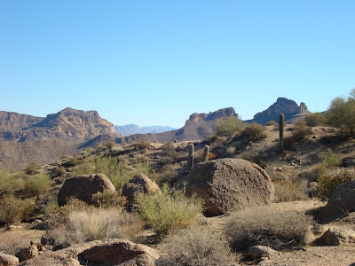
Towering at over 7,600 ft, Four Peaks Mountain stands as the most recognizable landmark on Phoenix's eastern horizon - proudly holding the title of highest peak in Maricopa County. Although Four Peaks Mountain is only 40 miles from the Phoenix area, unless you have a high-clearance vehicle, you will be stuck traveling approximately 80 miles (each way) to access the mountain.

After driving many miles out of the way and slowly following a ten-mile, single-laned (and often snow/ice-covered) dirt road, you eventually arrive at the Lone Pine Trailhead and the start of the Brown's Peak Trail. At 7,657 ft, Brown's Peak is the tallest of the Four Peaks, providing a challenging hike through oak and pine-filled forests.

Although the Brown's Peak Trail provides a gradual climb with beautiful vistas of the neighboring Superstition Mountains and Lake Roosevelt, the true highlight during the winter months is the chance for a snowy hike! Fortunately, with several inches of snow accumulation from earlier this month, the trail provided an exquisite winter wonderland yet maintained a clearly-marked path due to its vast popularity. Although I did not complete the full-hike to the mountain's top, the Brown's Peak Trail provided an afternoon of snowy fun that was pure delight!

To view more pictures of the Brown's Peak Trail, click here.

Tuesday, December 25, 2007

Hike #21: Hieroglyphic Trail, Superstition Wilderness, Tonto National Forest

Length: 6 miles (3 miles if you turn around at the petroglyphs)

Named for a series of Hohokam Indian petroglyphs - which early settlers mistook for Egyptian hieroglyphics, the Hieroglyphic Trail provides exciting hiking options for both the beginner and seasoned hikers. The first part of the trail is well-established and relatively flat, making it ideal for first-time hiker; the second, more challenging, half of the "trail" follows no set path, but instead provides a steep climb through unmarked terrain to the Superstition Ridgeline.

From the parking lot, follow the Lost Dutchman Trail for a couple hundred feet to a well-marked intersection with the Hieroglyphic Trail. Continue along the new trail through a beautiful desert landscape with the towering Superstitions in the background. The trail continues for about a mile and a half to a large series of pools, which are typically full during the winter and early spring. Carved into the stone cliffs next to these pools are the mysterious petroglyphs.

For those that desire an easy hike, now is the time to turn around; for the more adventurous, this is where the fun begins! From the petroglyphs, continue north following the boulder-filled wash. Although the trail has been easy-going so far, this segment will definitely take some time - many of the boulders are quite large and extremely difficult to pass. Following this path, you will soon pass an abandoned mine shaft before coming upon a fork in the wash. Unfortunately, finding the correct fork is apparently quite difficult...with so many drainage routes in the canyon, it's difficult to select the correct fork. I apparently did not do so well.

Leaving the main wash at the canyon's bottom, I began following a minor wash towards the ridgeline. Unfortunately, the path I was following soon became little more than a steep overgrown cliff. After working my way straight up (through some pretty scary spots) for a couple hours, I eventually had to give up and admit defeat. Sadly, getting down was even more difficult than the ascent; I was seriously beginning to wonder if I was going to make it back to the canyon's bottom in one piece! Thankfully, upon reaching the canyon's bottom, it's merely a matter of retracing your way through the boulders back to the established trail.

To view more pictures of the Hieroglyphic Trail, click here.

Friday, December 21, 2007

Hike #20: Picketpost Mountain Trail, Tonto National Forest

Length: 4.5 miles (this is the distance listed in my guide book....but it seemed much, much longer!)

Towering over the small town of Superior, just 40 miles east of the Phoenix area, Picketpost Mountain provides a steep hike that is as rewarding as it is challenging!

Starting from the parking lot, the trail begins by following a portion of the famous Arizona Trail; however, after about a half-mile, the Picketpost Mountain Trail turns to the left and begins a relatively steep climb towards the mountain. Winding through the desert low lands, the trail eventually narrows into a series of slippery, rock-covered switchbacks, which slowly lead to the base of the mountain.

From here, the real work begins! The trail quickly leaves the foothills and advances straight up the mountain side. Fortunately, the trail is well-marked with painted arrows....unfortunately, the vast majority of these arrows are pointing straight up. The next mile is an extremely challenging trek, which is a slow journey that requires much more scrambling than actual walking. My guidebook also warned of a "scary cliff"....it appeared to me that ALL the cliffs along this part were pretty darn scary!

Eventually, the trail flattens again as it reaches the grassy plateau. At the mountains summit is a rusty mailbox with the trips log books. Normally, the plateau provides an amazing view of the surrounding mountain ranges; unfortunately, the sky was completely overcast during my visit.

After enjoying a break at the top, it's time to return down the same path. Although one would expect the return trip to be as difficult as the incline, it actually turned out to be a quick, relatively easy trip, that only required labored scrambling in a few spots. Upon reaching the bottom you can look back in awe that you conquered Picketpost Mountain!

To view more pictures of the Picketpost Mountain Trail, click here.

Saturday, December 15, 2007

Hike #19: Pass Mountain Trail, Usery Mountain Park

Length: 7.4 miles

Located on the edge of the Phoenix Metro Area, just before the Superstition Mountains, Usery Mountain Park provides an environment which most would consider the quintessential Arizona. Although the park is better-known for the challenging Wind Cave Trail (which climbs the park's main feature - Usery Mountain), the lesser-traveled Pass Mountain Trail provides an alternative - and relatively easy - loop hike around the mountain's base.

Beginning from the county-controlled parking lots on the east side of the park, the trail begins by tracing its way through a lush desert landscape. With thousands of saguaro cacti growing from the surrounding sandy mounds, few places could be more stereotypical of the Sonoran Desert. The trail continues along this desert route for the first couple miles with little change.

After about two-miles, the trail turns west and begins a gradual incline. At the hill's summit, a majestic panoramic view of the Superstition Mountain begins to unfold before you! Eventually, a full view of the Superstition Ridgeline is directly before you with the even taller (and often snow-covered) Four Peaks Mountain looming in the background. This beautiful view persist for the next several miles as the trail slowly wraps itself around the west face of Usery Mountain.

Eventually, the trail again turns, leaving the Superstitions, and heading back towards the Metro Valley. The final miles are filled with wide views of the city and a return to the desert floor.

To see more pictures of the the Pass Mountain Trail, click here.