Saturday, February 6, 2016
Hike #50: Vineyard Trail #131, Tonto National Forest
Length: 7 miles (12 miles to terminus)
A drive to the Vineyard trail reminds one just how vast the Tonto National Forest really is! The Vineyard Trail starts at the edge of Roosevelt Lake, just north of the Theodore Roosevelt Dam. Although not geographically that far from the East Valley, the dam and trailhead are a bit of a trek due to the lack of a (good) direct route. To reach the trailhead, there are three possible driving routes. The most direct it to take the Apache Trail from Apache Junction as it traces its way along Canyon Lake and Apache Lake. Although beautiful, the majority of this road is curvy, unpaved mountain passes - which make for extremely slow travel! The fastest (though longer) options are the take either the Beeline Highway north to SR 188 or the 60 east to Globe and connect to the SR 188 there. Either of these routes provide an easy (fully-paved) route that will take you directly to the trailhead!
Once you arrive at Roosevelt Lake, the trail parking lot is a small lot along the lakeshore directly north of the fairly-new Roosevelt Bridge. From here, you must cross over the highway, and walk back towards the bridge. Passing along the roadway between the bridge's guardrails and the mountainside, there is a small sign marking the trailhead and an obvious trail that ascends the mountain.
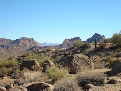
Surprisingly, the trail up Vineyard Mountain was a fairly easy ascent that rarely seems all that challenging - though that might have been helped with plenty of breaks to enjoy the beautiful panoramic views of Roosevelt Lake. The gravel trail continues upward through a desert thick with small cactus (especially prickly pears!) After reaching the top (where there is an abandoned reflector tower), you are rewarded with views of Roosevelt Dam before continuing along a much more level segment of the trail. As the trail gradually passes along the upper plateau, you begin to round the mountain away from Roosevelt Lake and instead enjoy glimpses of Apache Lake gleaming in the distances. Several larger boulders along this portion of the trail provide the perfect resting spot for a well-deserved break and a good view!
From here, the trail make a gradual descent and again turns so that you're facing Four Peaks in the north. Passing through a large grouping of saguaro cactus, the trail continues a level for at least a mile with little else to note. This was our turning point (since it was growing late in the afternoon), though the trail does continue for at least two miles (encountering a couple forest roads and a ridgeline walk.) Sadly, since the Vineyard trail is an out-and-back trail, we had no other option but retracing our steps back towards the trailhead; we had no problem with this, though we witnessed several people slipping on the loose gravel along the declines!)
To view more photos of Vineyard Trail, click here.
Saturday, June 12, 2010
Hike #49: East Webber Trail, Tonto National Forest
Located north of Payson just below the Mogollon Rim, the East Webber Trail provides a refreshingly cool, enjoyable walk through some extremely secluded woods. (Perhaps the main reason for the isolation is the fact that the only access to the East Webber Trail is via the Geronimo Trail, which when added to the East Webber Trail makes for a full 12-mile hike.)
Beginning at the trailhead for the Geronimo Trail, the trail briefly passes along the famous Highland Trail before connecting to an old jeep trail that has now become Geronimo Trail. Following this path, the trail slowing climbs through the surrounding forest for approximately 3-miles before connect with the remote East Webber Trail.
Following along East Webber Creek, the East Webber Trail is remarkably well-marked for a trail that seemingly sees so little traffic (the Boy Scout Camp located nearby is likely responsible for this.) The East Webber Trail is a pleasant little trail that works its way through some remarkably lush forest (the number of ferns and wildflowers along this trail was quite amazing); however the true star of this trail is the East Webber Creek itself. The trail repeatedly meanders back and forth across the creek, allowing for a perfect mixture of forest hike and water play. Unfortunately, the final segment of the East Webber Trail is overgrown and extremely difficult to navigate, so we were unable to complete the full trail. However, after a long rest along the creek banks, we did not feel too bad about returning to the trailhead - and I doubt our poor feet could have handled much more walking.
I will advise extra attention be paid at the initial segments of trails; after a long day of hiking, we had extreme difficulty remember where exactly we turned onto the Geronimo Trail (though had we just kept walking we would have realized all our worry was unnecessary - the trail could not have been more clearly marked.) Also make sure you return on the LEFT segment of the Highland Trail - we passed a good 20 minutes of rigorous climbing before we realized we'd headed the wrong direction. Still, the cool temperates, lush forests, and scenic creek made for an enjoyable day.
To view more photos of the East Webber Trail, click here.
Sunday, August 16, 2009
Hike #45: Babe Haught Trail, Tonto National Forest
Starting near the Tonto Creek Fish Hatchery nent to the vastly popular Horton Creek Trail, the Babe Haught Trail provides a challenging hike, which is extremely exposed and can be quite warm in the August heat!
Beginning at the base of the Rim, the trail almost immediately begins a study climb upwards. The first ½-mile is a relatively easy walk through tall grass; however, be on the lookout for the numerous cattle that apparently graze along this path (and watch even more closely for the cow manure hidden among the grass!)
Eventually, the cool grass parts and the real climb begins. Switchbacking along the Rim, the trail makes a rather steep climb directly up the face of the Rim. Although the heat is quite intense along this segment, the beautiful panoramic views are almost enough to make one forget the discomfort. Fortunately, once reaching the top of the Rim, the temperature makes a sudden drop and the wind can be quite intense.
From the Rim top, the trail becomes much less developed; fortunately, numerous cairns and the occasional marked-tree make the path follow-able if watch carefully. For this final segment of the trail enters the forest, where due to the isolation of the path, there are great opportunities to view wildlife. Eventually, the trail exits onto FR300 and continues into the Coconino National Forest. Unfortunately, I did not continue on past the forest road; however, I have read that there is a nice lake at the trail's end.
To view more photos of the Babe Haught Trail, click here.
Saturday, July 25, 2009
Hike #44: See Canyon Trail, Tonto National Forest
Just below the Mogollon Rim east of Payson, the See Canyon Trail works it's way through the dense forest along the Christopher Creek and eventually climbs to the Rim's top.
Beginning alongside the creek, the first ½-mile follows a relatively open path surrounded by thick knee-high grass. Due to the proximity to the cool creek, this segment of the trail is immensely popular and likely to be quite crowded; however, the trail soon forks and most people will choose to follow the shorter path leading to the See Canyon Springs (in fact, after this intersection I didn't encounter anyone along the next 3-miles of trail!)
Eventually the trail leaves the main creek bed, following a much smaller stream, which eventually becomes nothing more than a dry riverbed. Along this portion of the trail, the forest becomes quite dense, and the trail can be difficult to follow in many spots; numerous fallen trees and large boulders don't make the passage much easier.
After a couple miles of gradual assent, the trail comes upon the Mogollon Rim and makes a more dramatic climb through slightly less-dense woodlands. Although one expects an amazing Rim view after the difficult climb, the only site to view is a well-traveled forest road. After a brief moment of disappointment at encountering nothing more than a forest road, it's time to turn and follow the same path back to the creek and trailhead.
To view more photos of the See Canyon Trail, click here.
Saturday, July 4, 2009
Hike #42: Fossil Springs Trail, Fossil Springs Wilderness
Located just north of Payson near the small town of Strawberry, the Fossil Springs Trail is commonly listed among Arizona’s best summer hikes. However, with higher July temperatures (85+) and little shade along the way, the Fossil Springs Trail can be a brutal experience better saved for late spring or fall…
The trail begins with a study descent, which grows more and more steep as the trail progresses. Although the distant views of the Mogollon Rim are somewhat impressive, the immediate trail surroundings leave a lot to be desired. The first three miles of this trail offers little more than scrawny trees and cactus. The one interesting aspect was the numerous plants in bloom; excellent examples of both agave and prickly-pears were standing in full bloom!
However, after the first three-miles, the trail reaches the basin's floor, and the true beauty begins. Following along the dry stream bed, the trail continues west for about a ½-mile before one actually encounters the spring water. Beginning with a series of shallow pools, the water-level gradually grows the further one continues along. (When the "river" first begins, the trail crosses the stream and continues along the right bank. While you can continue scrambling along the stream bed, the official trail leads away from the water and continues for the final ½-mile.)
Eventually, the trail will lead to a magnificent waterfall, which marks the end of the trail. Climbing down the rather steep riverbanks, allows one an excellent resting place beside an interesting grotto just downstream from the falls. Although views of the waterfall are blocked from the grotto, one can scramble along the north bank for an amazing view at the foot of the falls.
After a well-earned break/swim, you must now retrace your steps for the difficult climb back to the trailhead. While the original descent made the trail seem extremely easy, the return can prove quite difficult due to the trail's steepness; general fatigue from the trip down; and the afternoon heat, which can be quite oppressive.
To view more photos of the Fossil Springs Trail, click here.
Sunday, June 1, 2008
Hike #36: Horton Creek Trail, Tonto National Forest
Well, the thing I most feared finally happened...I got about 50 miles outside the Phoenix area when I suddenly realized that I hadn't brought my camera! Had I been by myself, I might have considered just turning around and forgetting the hike; however, since I was with a friend, I decided that it would probably be best just to continue onward. I did, however, decide to alter my hiking plans so that I repeated a previous hike rather than continue to a completely new trail without the ability to record my adventure photographically!
I had originally hoped to hike the Fossil Creek Trail just north of Payson near the town of Strawberry; instead, I chose to re-hike the Horton Creek Trail just 20 miles east of Payson. My last visit to Horton Creek was in the Fall, so the warmer Spring weather did provide a completely different perspective. The trail still provided the same dramatic views of the creek as is cascades down the mountain-side. However, on this trip, there was the added beauty from an abundance of wildflowers; I wish I could have identified more of them, but the only ones I could definitely identify were the numerous pink wild roses!
Although I did remember the fantastic views of Horton Creek, I somehow failed to remember the significant incline of the trail! The full length of this trail (to the spring) is approximately 8.5 miles roundtrip. Unfortunately, I decided against hiking the whole trail, instead choosing to turn around after 2.5 miles.
Sunday, April 6, 2008
Hike #32: Butcher Jones Trail, Tonto National Forest
On my last visit to the Butcher Jones Trail, I had considerable trouble locating the correct path. I believe the lake's level was significantly raised due to the draining of a dam upstream, resulting in a crudual segment of the trail being submerged below the lake and reeds. Fortunately, on this trip, the lake was again at a normal level, and the trail was easily followed.
The first half-mile of the Butcher Jones Trail merely traces the western shoreline of Saguaro Lake, which is extremely popular with anglers on most weekends. Fortunately, the trail soon leaves the shore and begins working its way into the more secluded surrounding hills.
I was completely amazed at the number and variety of wildflowers growing along these hills. With the wildflower season beginning at the end of February when the Valley is still cool and relatively wet, the presence of so many flowers took me by completely surprise; in fact, I would say there is an even large abundance of flowers now than existed a month ago! I'm glad to see the warmer, drier weather hasn't effected everything in nature the way it's knocked me out the past couple weeks (darn these allergy/sinus issues!!!)
Once the trail enters the hills above the lake, the surroundings become more and more like those one would expect to see in the Phoenix Valley; however, the lake is never far from sight, and the trail eventually leads down to the shoreline once again. After enjoying the beautiful flowers and scenic views, return to the trailhead along the same path you've been following. (However, be forewarned that if you descend from the first set of hills to the second area of shoreline, it will be a fairly steep hike on your way out!)
To view more photos of the Butcher Jones Trail, click here.
Thursday, March 20, 2008
Hike #31: Jacob Crosscut Trail, Superstition Wilderness
When I set out this morning, I intended to re-visit the Massacre Grounds Trail; however, on the way to the trailhead, I spotted the smooth parking area for the Crosscut Trail and quickly altered my plans to avoid the miles of rough dirt road!
The Crosscut Trail starts runs along the north-side of the Superstition Mountain, with the trail starting near the First Water Trailhead and ending in Apache Junction. If hiked in its entirety, the Crosscut Trail runs just over 6-miles (most of it passing through the Lost Dutchman State Park). I, however, followed the trail for approximately 1-mile until it intersects with a segment of the Treasure Loop Trail inside the Lost Dutchman State Park; this made for a relaxing, relatively flat balloon trail through beautiful spring wildflowers and scenic mountain views.
To view more pictures of the Crosscut Trail, click here.
Friday, February 22, 2008
Hike #29: Wind Cave Trail, Usery Mountain Park, Tonto National Forest
Although I greatly enjoyed my last visit to Pass Mountain, I was fully prepared for a great disappointment with the Wind Cave Trail. One of the things I enjoyed most about my Pass Mountain Trail was the amazing views of the Superstition Wilderness on the east side of the mountain; since the Wind Cave Trail is entirely on the west side of the mountain, I was fully prepared for a mundane hike. Fortunately, with the help of some beautiful spring flora, the Wind Cave Trail proved an enjoyable and unexpected desert adventure.
The Wind Cave Trail begins in the the Usery Mountain Park, one of the county-controlled parks. Although this area is normally your stereotypical desert with little more than sand and prickly cactus, with the recent winter rains, the desert floor had been transformed into a sea of green with scattered bursts of wildflowers! Working your way towards the mountain, you gradually begin climbing along a series of switchbacks leading to the easily-recognizable strip of yellowish exposed rock 2/3 the way up Pass Mountain. Wind erosion has slowly cut away this rock to form Wind Cave, a small cavern on the south side of the mountain.
Although Wind Cave is the official end of the trail, those more adventurous might choose to continue another half-mile towards the peak of Pass Mountain. Although the trail is slightly more difficult after the cave, numerous spray-paint arrows and a rather well-worn path make the assent relatively painless. Once at the peak, there is a commanding view of both the Superstition Wilderness to the east and the entire Phoenix Valley to the west. (Unfortunately, the sky was completely overcast during my visit, so the view was considerably diminished.) From here, merely retrace the trail back to the park entrance.
To view more photos of the Wind Cave Trail, click here.
Sunday, February 17, 2008
Hike #28: Siphon Draw Trail to Flatiron, Superstition Wilderness, Tonto National Forest
Starting at the Lost Dutchman State Park, the Siphon Draw Trail provides an extremely strenuous climb up the Superstition Mountain. Although the Siphon Draw Trail is quite difficult, the convenient start point and trail's beauty make it very popular (and often quite crowded.)
The first mile of the trail passes through the Lost Dutchman State Park and is extremely well-maintained; this segment of the trail is a luxurious dirt path with well-defined rock borders. However, the trail soon leaves the state park and enters the Superstition Wilderness. While the trail continues with a well-marked route, the path is no long the smooth dirt but instead a series of small loose rocks. The trail climbs higher and higher getting ever more narrow and rough.
Eventually, the trail arrives at a large smooth stone basin, which after a heavy rain will have small streams of water cascading down its sides. To the left of the basin is a large waterfall which marks the official end of the Siphon Draw Trail. Although most people choose this as the turn-around point, a good many continue climbing along the unofficial "trail" towards Flatiron, a large, flat plateau on the top of the Superstition Mountain.
The unofficial trail is quite easy to follow thanks to heavy travel and a series of white spray-painted arrows and dots. Although few route finding skills are required, the difficulty of climbing makes this one of the most challanging trails in the Superstitions. The mile between the waterfall and the top of the mountain gains over 1,500 feet in elevation and is nothing more than a continuous climb up jagged rocks. Although this part is challanging and will get the heart pounding, the rocks do provided a nice climbing surface with plenty of places to clutch as you drag yourself up the mountain.
Finally, after climbing until you think you can go no further, you arrive at a 12-foot rock wall that proves to be the most difficult obstacle yet! Although not impossible this rock wall is by far the most vertical challenge encountered on this trail. Fortunately, immediately on the other side of this wall is the top of the Superstition Mountain and a large flat plateau (and trust me, after climbing for what seems like forever, the flat land will be something to rejoice over!)
The large plateau area to the right of the trail is known as Flatiron, and provides thrilling views of the entire Superstition Wilderness and Phoenix Valley. Flatiron makes a perfect resting point, although I'd advice those with vertigo to stay away from the plateau's steep cliffs! After a well-deserved rest, it is time to retrace your steps down the mountain. Although not as physically exhausting, the route down requires careful footwork and can take considerable time. However, once arriving back at the waterfall and stone basin, the smooth, well-developed trail returns for a speedy exit.
To view more pictures of the Siphon Draw Trail, click here.
Saturday, February 2, 2008
Hike #26: Pine Creek Loop to Ballantine Trail, Tonto National Forest
The trail begins with the short Pine Creek Loop, which loops 1.5 miles either way to intersect with the start of the Ballantine Trail. My guidebook recommended starting with the southern segment of the loop; however, this segment was quite a steep climb and probably would be better saved for a downhill finish!
Whichever route you've chosen, the clearly-marked intersection for the Ballantine Trail is soon approached and the trail leaves the original loop - curving east with the Camp Creek sparkling far below. The Ballantine trail continues along the creek's path, slowly working it's way down toward the valley floor. Almost immediately after meeting the Ballantine Trail, the path becomes surrounded by large formations of boulders - some in quite interesting shapes (perhaps a woman playing hide-n-seek, as my friend pointed out.)
After a couple miles, a large mountain of crumbling rocks, known as "The Boulders", looms to the right. Near the eastern base of The Boulders is a fork in the trail, with a faint, but well-marked trail heading toward to the right. Following the numerous rock cairns, the trail soon crosses the creek, and continues around The Boulders. With breathtaking views of the Superstitions in the distance, the trail soon turns and the third and final creek comes into view. The end of this trail is a small waterfall that tumbles over a series of boulders, making the perfect location for a well-deserved break. From this point, it's merely a matter of turning and retracing your way back to the Pine Creek Loop and the original trailhead.
To view more photos of the Pine Creek Loop and Ballantine Trail, click here.
Saturday, January 19, 2008
Hike #24: Palo Verde Trail, Tonto National Forest
Bartlett Lake, formed by the damming of the Verde River, is the second largest lake developed by the Salt River Project and a major recreation area in the Phoenix area. The Palo Verde Trail, which runs along the lake's shore, provides an enjoyable, yet relatively isolated, hike among lush riparian land.
Beginning at Rattlesnake Cove (a large recreation area along the lake), the Palo Verde Trail turns left at the large dock and works its way along a well-worn path. The trail weaves it's way through some thick growth until it comes to a series of rugged cliffs. Continuing along the coastline past many wood-littered beaches and through multiple washes, the trail passes through the surrounding hills with the lake resting immediately to the right.
Eventually, the trail comes to a major wash and forks. The trail to the left heads away from the shore and provides a shortcut to the turn-around point; the trail to the right is much lengthier and continues tracing the shoreline much as the trail had done for the previous miles. At this point, I was ready to travel the shortest path possible to end this journey. Unfortunately, the shortcut was not so easily followed (even with multiple trail markers), and I merely decided to turn around and end the hike a mile early.
To view more photos of the Palo Verde Trail, click here.
Saturday, January 12, 2008
Hike #23: Massacre Grounds Trail, Superstition Wilderness, Tonto National Forest
Located immediately east of the Phoenix Metro Area and just miles from the Black Mesa Loop Trail, the Massacre Grounds Trail provides a short, moderately-challenging hike through the Superstition Wilderness. Unfortunately, this trail is not the easiest to access; the rough road leading to the trailhead is extremely primitive and requires either a high-clearance vehicle or some slow, careful driving. However, upon reaching the trailhead, it quickly becomes evident by the breath-taking view that the drive was well worth it!
The Massacre Grounds Trail begins along a relatively flat plain with the Superstition Mountains rising in the foreground and the massive Four Peaks Mountain towering in the distance. The trail soon works its way away from this plain and enters a series of valleys with dramatic peaks on each side. Although the peaks are each impressive, it is a solitary needle formation that commands the scene. After about a half mile, the trail passes the side of this needle and continues deeper and steeper into the Superstitions.
After passing the striking needle formation, the trail quickly begins following a boulder-filled wash, which if there's been a recent rain will be filled with water. After skipping among the shallow pools for another half-mile, the trail approaches a small waterfall (again, provided that there's has been significant rain.) Up until this point, the trail has been really well-defined; however, after the waterfall the trail makes a sharp turn left and all but disappears.
Carefully following the rock cairns through shrub-covered desert, the trail climbs for the next mile until it reaches a large rocky cliff. From here, there is yet another panoramic view of the surrounding desert. After a brief break at the top, it's time to turn around and retrace your steps back to the parking lot. Sounds easy, right? Guess again! I somehow lost the trail on the way down. I worked my way across open desert - through several washes - until the original needle came into view again. (Too bad I was way too far to the west!) Fortunately, once I could see the needle again, I had a point of reference and merely had to work my way towards its base.
To view more pictures of the Massacre Grounds Trail, click here.
Saturday, December 29, 2007
Hike #22: Brown's Peak Trail, Four Peaks Wilderness, Tonto National Forest
Towering at over 7,600 ft, Four Peaks Mountain stands as the most recognizable landmark on Phoenix's eastern horizon - proudly holding the title of highest peak in Maricopa County. Although Four Peaks Mountain is only 40 miles from the Phoenix area, unless you have a high-clearance vehicle, you will be stuck traveling approximately 80 miles (each way) to access the mountain.
After driving many miles out of the way and slowly following a ten-mile, single-laned (and often snow/ice-covered) dirt road, you eventually arrive at the Lone Pine Trailhead and the start of the Brown's Peak Trail. At 7,657 ft, Brown's Peak is the tallest of the Four Peaks, providing a challenging hike through oak and pine-filled forests.
Although the Brown's Peak Trail provides a gradual climb with beautiful vistas of the neighboring Superstition Mountains and Lake Roosevelt, the true highlight during the winter months is the chance for a snowy hike! Fortunately, with several inches of snow accumulation from earlier this month, the trail provided an exquisite winter wonderland yet maintained a clearly-marked path due to its vast popularity. Although I did not complete the full-hike to the mountain's top, the Brown's Peak Trail provided an afternoon of snowy fun that was pure delight!
To view more pictures of the Brown's Peak Trail, click here.
Tuesday, December 25, 2007
Hike #21: Hieroglyphic Trail, Superstition Wilderness, Tonto National Forest
Named for a series of Hohokam Indian petroglyphs - which early settlers mistook for Egyptian hieroglyphics, the Hieroglyphic Trail provides exciting hiking options for both the beginner and seasoned hikers. The first part of the trail is well-established and relatively flat, making it ideal for first-time hiker; the second, more challenging, half of the "trail" follows no set path, but instead provides a steep climb through unmarked terrain to the Superstition Ridgeline.
From the parking lot, follow the Lost Dutchman Trail for a couple hundred feet to a well-marked intersection with the Hieroglyphic Trail. Continue along the new trail through a beautiful desert landscape with the towering Superstitions in the background. The trail continues for about a mile and a half to a large series of pools, which are typically full during the winter and early spring. Carved into the stone cliffs next to these pools are the mysterious petroglyphs.
For those that desire an easy hike, now is the time to turn around; for the more adventurous, this is where the fun begins! From the petroglyphs, continue north following the boulder-filled wash. Although the trail has been easy-going so far, this segment will definitely take some time - many of the boulders are quite large and extremely difficult to pass. Following this path, you will soon pass an abandoned mine shaft before coming upon a fork in the wash. Unfortunately, finding the correct fork is apparently quite difficult...with so many drainage routes in the canyon, it's difficult to select the correct fork. I apparently did not do so well.
Leaving the main wash at the canyon's bottom, I began following a minor wash towards the ridgeline. Unfortunately, the path I was following soon became little more than a steep overgrown cliff. After working my way straight up (through some pretty scary spots) for a couple hours, I eventually had to give up and admit defeat. Sadly, getting down was even more difficult than the ascent; I was seriously beginning to wonder if I was going to make it back to the canyon's bottom in one piece! Thankfully, upon reaching the canyon's bottom, it's merely a matter of retracing your way through the boulders back to the established trail.
To view more pictures of the Hieroglyphic Trail, click here.
Friday, December 21, 2007
Hike #20: Picketpost Mountain Trail, Tonto National Forest
Towering over the small town of Superior, just 40 miles east of the Phoenix area, Picketpost Mountain provides a steep hike that is as rewarding as it is challenging!
Starting from the parking lot, the trail begins by following a portion of the famous Arizona Trail; however, after about a half-mile, the Picketpost Mountain Trail turns to the left and begins a relatively steep climb towards the mountain. Winding through the desert low lands, the trail eventually narrows into a series of slippery, rock-covered switchbacks, which slowly lead to the base of the mountain.
From here, the real work begins! The trail quickly leaves the foothills and advances straight up the mountain side. Fortunately, the trail is well-marked with painted arrows....unfortunately, the vast majority of these arrows are pointing straight up. The next mile is an extremely challenging trek, which is a slow journey that requires much more scrambling than actual walking. My guidebook also warned of a "scary cliff"....it appeared to me that ALL the cliffs along this part were pretty darn scary!
Eventually, the trail flattens again as it reaches the grassy plateau. At the mountains summit is a rusty mailbox with the trips log books. Normally, the plateau provides an amazing view of the surrounding mountain ranges; unfortunately, the sky was completely overcast during my visit.
After enjoying a break at the top, it's time to return down the same path. Although one would expect the return trip to be as difficult as the incline, it actually turned out to be a quick, relatively easy trip, that only required labored scrambling in a few spots. Upon reaching the bottom you can look back in awe that you conquered Picketpost Mountain!
To view more pictures of the Picketpost Mountain Trail, click here.Saturday, December 15, 2007
Hike #19: Pass Mountain Trail, Usery Mountain Park
Located on the edge of the Phoenix Metro Area, just before the Superstition Mountains, Usery Mountain Park provides an environment which most would consider the quintessential Arizona. Although the park is better-known for the challenging Wind Cave Trail (which climbs the park's main feature - Usery Mountain), the lesser-traveled Pass Mountain Trail provides an alternative - and relatively easy - loop hike around the mountain's base.
Beginning from the county-controlled parking lots on the east side of the park, the trail begins by tracing its way through a lush desert landscape. With thousands of saguaro cacti growing from the surrounding sandy mounds, few places could be more stereotypical of the Sonoran Desert. The trail continues along this desert route for the first couple miles with little change.
After about two-miles, the trail turns west and begins a gradual incline. At the hill's summit, a majestic panoramic view of the Superstition Mountain begins to unfold before you! Eventually, a full view of the Superstition Ridgeline is directly before you with the even taller (and often snow-covered) Four Peaks Mountain looming in the background. This beautiful view persist for the next several miles as the trail slowly wraps itself around the west face of Usery Mountain.
Eventually, the trail again turns, leaving the Superstitions, and heading back towards the Metro Valley. The final miles are filled with wide views of the city and a return to the desert floor.
To see more pictures of the the Pass Mountain Trail, click here.
Saturday, November 24, 2007
Hike #18: Peralta/Cave Trail Loop, Superstition Wilderness
The Peralta Trail is perhaps the most popular trail in the Superstition Wilderness, which when combined with the Cave Trail, makes for a spectacular loop hike that highlights the best the Superstitions Mountains have to offer.
From the busy parking lot, the loop begins by following the Peralta Trail through a lush green valley, which was quite the unexpected sight in the middle of the desert. After about a half-mile, however, the trail leaves the valley and begins a steady climb into the surrounding cliffs. For two-miles the trail creeps slowly up the mountain until suddenly making a turn and opening to a magnificent view of Weaver's Needle.
From this point, most people choose to turn around and retrace the Peralta Trail back to the parking lot. However, for the more adventurous, there is the somewhat longer (and much more difficult) Cave Trail. When first venturing onto the Cave Trail, the first thing one notices is the isolation; after the crowds of the Peralta Trail, the peace and quiet is almost startling.
Continuing along the Cave Trail is quite easy for the first mile; however, eventually the trail approaches a steep ridge, which you must somehow descend. Once at the bottom, the trail all but disappears. For the next mile, you must carefully follow the small cairns that mark the "trail" (and trust me this is not an easy thing to do...the terrain is extremely rough and many of the cairns are extraordinarily small and difficult to find!) I would not recommend taking this portion of the trail unless you feel very comfortable in your route finding skills (and preferably only in a group!)
Eventually, the Cave Trail does work its way down from the hard volcanic rocks into the more traditional desert, where the trail again becomes visible. From here, it is an easy trip back toward the Peralta trail and an easy exit.
To view more photos of the Peralta and Cave Trails, click here.
Saturday, November 17, 2007
Hike #16: Cave Creek/Skunk Tank Loop Trail, Tonto National Forest
The Cave Creek/Skunk Tank Trail, though quite long and challenging, provides a welcome break from the typical desert climate one expects so close to Phoenix.
Beginning at the popular Seven Springs Campground, the loop begins by following the Cave Creek Trail along the banks of Cave Creek. In the late fall (mid-November), this area will be easily identifiable by the rich gold color of the fall foliage from the various non-desert vegetation growing along the creek bed. (Several of the guide books state that this area is also rich in wildlife and that it is quite common to see or hear javalinas among these riparian areas - sadly I did not encounter any major wildlife.)
The trail continues along this path, repeatedly climbing the hills adjacent to the creek and then falling back towards the creek and valley bottom. Although this portion of the trail does require one to cross the creek three times, the water is generally extremely shallow and poses little difficulty when crossing. Unfortunately, finding the correct spots to actually cross is by no means anywhere as easy! Be on the lookout for the small rock cairns marking the crossings...otherwise you'll never find the proper spots. (I spent 30 minutes trying to locate the third crossing...and still ended up having to climb a steep, overgrown slope to land on the established trail again.)
Shortly after the third creek crossing, the Cave Creek Trail intersects the Skunk Tank Trail. From here, you can either turn around and retrace your way back over the easy Cave Creek Trail, or continue along the more difficult Skunk Tank Trail.
The Skunk Tank Trail immediately begins with a two-mile climb into the mountains away from the creek. The first mile or so isn't so bad due to a nice breeze common at the higher elevations; however, you soon turn between two mountains, and this breeze completely disappears for the next mile or so (making for one blisteringly hot climb!) Although the Skunk Tank Trail does provide a nice panoramic view at the top, it can by no means match the beauty of the Cave Creek. My advice would be, unless you desire a challenging workout, turn around where the Cave Creek and Skunk Tank Trails meet and enjoy a leisurely return hike along the creek!
To view more pictures of the Cave Creek/Skunk Tank Loop Trail, click here.
Sunday, November 11, 2007
Hike #15: Black Mesa Loop Trail, Superstition Wilderness
The Black Mesa Loop Trail is actually three trails, the Lost Dutchman Trail, the Black Mesa Trail, and the First Water Trail, which when combined make for challenging 9-mile hike.
The loop begins by following the Lost Dutchman Trail for about 4.5 miles. With a variety of desert vegetation and breath-taking views, this is by far the best portion of the loop. The cliffs overlooking the trail provide welcome shade along the first segment of the hike; however, after a couple miles of gradual incline, the trail leaves the cliffs and opens for a wide panoramic mountain view. After another couple miles, the trail approaches a large flat wash, where it intersects with the Black Mesa Trail. (Note: This can be really difficult to find since the trail all but disappears in the wash. Know that if you come upon the sign for Boulder Canyon Trail, you have gone too far and need to retrace the trail back about 500 yards until you see the wooden marker for the Black Mesa Trail.)
The Black Mesa Trail is the middle 3-miles of this loop. Although this segment of the loop does provide a good variety of vegetation, the views are nothing when compared to those of the first portion. I will advise to watch out for the forests of Jumping Cholla Cactus, which have VERY prickly barbs.
Eventually, the vegetation grows more sparse, and the loop connects with the final 1.5-miles of the First Water Trail. Although this portion passes through a couple minor washes, it is otherwise unremarkable.
To see more pictures of the Black Mesa Loop Trail, click here.